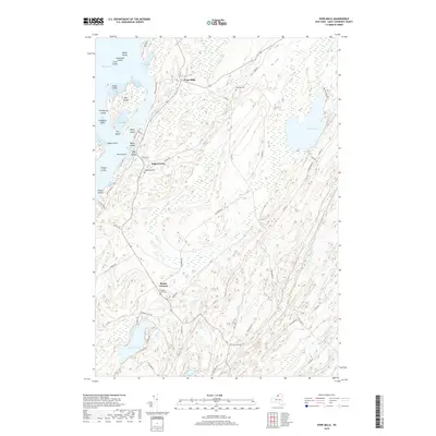
2019 Map of Pope Mills
USGS Topo · Published 2019About this map
Black Lake defines the western edge of this landscape, its shoreline deeply indented by bays and peppered with islands like Snake Island and Big Island. This region of Saint Lawrence County is characterized by a series of northeast-trending ridges and wetlands, where the drainage of Fish Creek and Birch Cr flows toward the Oswegatchie River. Small rural hubs such as Pope Mills and Brasie Corners serve as the primary points of settlement, connected by a network of county roads that navigate the complex hydrography. The map records several local burying grounds, including Oldsville Cem and Woodworth Cem, which are vital for genealogical research in this part of New York. The presence of Hickory Lake and Pleasant Lake further emphasizes the water-dominant nature of the terrain, illustrating the persistence of small-scale agricultural and residential patterns in the north country.
Find a feature on this map
72 named features on this map. Tap any name to fly to it.
Don’t see what you’re looking for? This feature index may not catch every label — zoom into the map to look around manually.
Map Details
Editions of this 2019 Pope Mills Map
This is the sole edition of this map. No revisions or reprints were ever made.
Other maps of this area

1904 · Ogdensburg
USGS Topo · 1:62,500

1905 · Ogdensburg
USGS Topo · 1:62,500

1906 · Brier Hill
USGS Topo · 1:62,500

1912 · Hammond
USGS Topo · 1:62,500

1915 · Gouverneur
USGS Topo · 1:62,500

1937 · Gouverneur
USGS Topo · 1:62,500

1942 · Morristown
USGS Topo · 1:24,000

1943 · Morristown
USGS Topo · 1:31,680

1943 · Edwardsville
USGS Topo · 1:31,680
1943 · Heuvelton
USGS Topo · 1:31,680