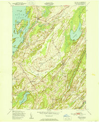
1951 Map of Pope Mills
USGS Topo · Published 1951About this map
Pope Mills sits at the junction of Fish Creek and the southern reach of Black Lake in this mid-century portrait of St. Lawrence County. The landscape is defined by the elongated ridges and wetlands of the northern New York frontier, where small rural communities like Brasie Corners and Pierces Corners are connected by winding country roads. The map reveals a robust network of local education, with numerous district schoolhouses such as California School, Stark Sch, and Bigelow School serving the scattered farmsteads of Macomb and Gouverneur townships.
Find a feature on this map
33 named features on this map. Tap any name to fly to it.
Don’t see what you’re looking for? This feature index may not catch every label — zoom into the map to look around manually.
Map Details
Editions of this 1951 Pope Mills Map
This is the sole edition of this map. No revisions or reprints were ever made.
Other maps of this area

1904 · Ogdensburg
USGS Topo · 1:62,500

1905 · Ogdensburg
USGS Topo · 1:62,500

1906 · Brier Hill
USGS Topo · 1:62,500

1912 · Hammond
USGS Topo · 1:62,500

1915 · Gouverneur
USGS Topo · 1:62,500

1937 · Gouverneur
USGS Topo · 1:62,500

1942 · Morristown
USGS Topo · 1:24,000

1943 · Morristown
USGS Topo · 1:31,680

1943 · Edwardsville
USGS Topo · 1:31,680
1943 · Heuvelton
USGS Topo · 1:31,680