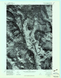
1977 Map of Poplar Mountain
USGS Topo · Published 1983About this map
The Carrabassett River carves a distinct corridor through this stretch of the Maine woods, serving as the primary geographic anchor for small clearings and settlements. This 1977 orthophotoquad provides an unfiltered aerial perspective of the landscape as it appeared in the late 1970s, highlighting the precise footprints of Records, Carrabassett, and Spring Farm. Unlike traditional topographic maps, this imagery reveals the specific density of the forest canopy and the exact placement of structures along the river valley.
Find a feature on this map
10 named features on this map. Tap any name to fly to it.
Don’t see what you’re looking for? This feature index may not catch every label — zoom into the map to look around manually.
Map Details
Editions of this 1977 Poplar Mountain Map
This is the sole edition of this map. No revisions or reprints were ever made.
Other maps of this area

1928 · Dead River
USGS Topo · 1:62,500

1928 · Stratton
USGS Topo · 1:48,000

1929 · Phillips
USGS Topo · 1:48,000

1930 · Kingfield
USGS Topo · 1:48,000

1931 · Dead River
USGS Topo · 1:48,000

1932 · Phillips
USGS Topo · 1:62,500

1932 · Stratton
USGS Topo · 1:62,500

1932 · Kingfield
USGS Topo · 1:62,500

1944 · Dead River
USGS Topo · 1:62,500

1949 · Jackman
USGS Topo · 1:250,000
Featured Places
- Kingfield, ME
- Carrabassett Valley, ME
- Highland Plantation, ME
- Lexington Township, ME
- Dead River Township, ME