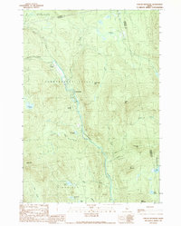
1989 Map of Poplar Mountain
USGS Topo · Published 1989About this map
The Carrabassett Valley defines the core of this late-twentieth-century landscape, where the Carrabassett River flows through a corridor between high peaks. This area serves as a primary artery for small settlements like Carrabassett and Spring Farm, which appear alongside the more isolated Records in the northern valley. The topography is dominated by significant elevations, including Poplar Mtn, Little Poplar Mtn, and Ira Mountain, providing a clear view of the drainage patterns for numerous mountain streams such as Poplar Stream and Clay Brook. In the southern reaches, the township of Kingfield encompasses several water bodies like Shiloh Pond, Grindstone Pond, and Tufts Pond. The presence of several gravel pits near the riverbanks suggests the local reliance on road maintenance and small-scale industry within this wooded, mountainous section of Franklin County.
Find a feature on this map
36 named features on this map. Tap any name to fly to it.
Don’t see what you’re looking for? This feature index may not catch every label — zoom into the map to look around manually.
Map Details
Editions of this 1989 Poplar Mountain Map
This is the sole edition of this map. No revisions or reprints were ever made.
Other maps of this area

1928 · Dead River
USGS Topo · 1:62,500

1928 · Stratton
USGS Topo · 1:48,000

1929 · Phillips
USGS Topo · 1:48,000

1930 · Kingfield
USGS Topo · 1:48,000

1931 · Dead River
USGS Topo · 1:48,000

1932 · Phillips
USGS Topo · 1:62,500

1932 · Stratton
USGS Topo · 1:62,500

1932 · Kingfield
USGS Topo · 1:62,500

1944 · Dead River
USGS Topo · 1:62,500

1949 · Jackman
USGS Topo · 1:250,000
Featured Places
- Kingfield, ME
- Carrabassett Valley, ME
- Highland Plantation, ME
- Lexington Township, ME
- Dead River Township, ME