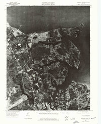
1973 Map of Poquoson West
USGS Topo · Published 1977About this map
The tidal landscape of the Virginia Peninsula appears in stark detail through this 1973 orthophotoquad, which uses rectified aerial imagery to document the interface between land and water. The York River dominates the northern edge of the sheet, providing a backdrop for the residential and industrial development taking hold along the jagged shoreline. In the southeast, the settlement of Poquoson is visible as a developing network of streets and neighborhoods carved out of the marshes and wooded inlets. Unlike a traditional line-drawn map, this photographic survey reveals the physical footprint of industry near the coast, including large storage tanks and cleared sites, while capturing the dense residential patterns emerging as the area transitioned from its maritime and agricultural roots into a modern suburban community.
Find a feature on this map
2 named features on this map. Tap any name to fly to it.
Don’t see what you’re looking for? This feature index may not catch every label — zoom into the map to look around manually.
Map Details
Editions of this 1973 Poquoson West Map
This is the sole edition of this map. No revisions or reprints were ever made.
Other maps of this area

1906 · Williamsburg
USGS Topo · 1:62,500

1907 · Yorktown
USGS Topo · 1:62,500

1907 · Hampton
USGS Topo · 1:62,500

1916 · Mathews
USGS Topo · 1:62,500

1917 · Mathews
USGS Topo · 1:62,500

1943 · Yorktown
USGS Topo · 1:62,500

1943 · Richmond
USGS Topo · 1:250,000

1944 · Hampton
USGS Topo · 1:24,000

1944 · Yorktown
USGS Topo · 1:24,000

1944 · Messick
USGS Topo · 1:24,000