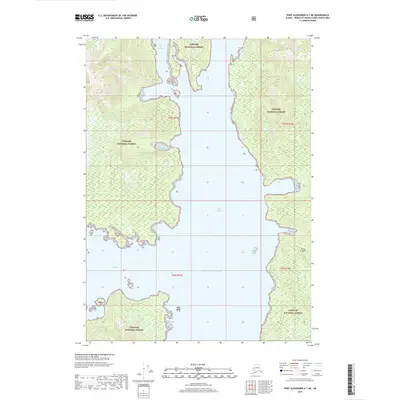
2017 Map of Port Alexander A-1 NE
USGS Topo · Published 2017About this map
Kuiu Island dominates this maritime landscape, where the sheltered waters of the Tongass National Forest meet the open Gulf of Alaska. The intricate coastline is defined by deep inlets such as Affleck Canal, which separates large landmasses, and smaller protected areas like Bear Harbor and Kell Bay. These topographical features provided essential refuge for coastal navigation and early maritime activities in the Alexander Archipelago. Small landform details, including the Bush Islets, offer specific points of reference for those studying the navigational history of these northern waterways. The map illustrates the dominance of federal forest lands over the region, showing how the coastal geography dictated the patterns of movement and potential settlement in this part of Southeast Alaska.
Find a feature on this map
11 named features on this map. Tap any name to fly to it.
Don’t see what you’re looking for? This feature index may not catch every label — zoom into the map to look around manually.
Map Details
Editions of this 2017 Port Alexander A-1 NE Map
This is the sole edition of this map. No revisions or reprints were ever made.
Other maps of this area

1948 · Petersburg A-6
USGS Topo · 1:63,360

1948 · Port Alexander A-1
USGS Topo · 1:63,360

1948 · Petersburg B-6
USGS Topo · 1:63,360

1948 · Port Alexander B-1
USGS Topo · 1:63,360

1951 · Port Alexander
USGS Topo · 1:250,000

1951 · Petersburg B-6
USGS Topo · 1:63,360

1951 · Petersburg A-6
USGS Topo · 1:63,360

1952 · Petersburg
USGS Topo · 1:250,000

1952 · Port Alexander
USGS Topo · 1:250,000
1953 · Port Alexander B-1
USGS Topo · 1:63,360