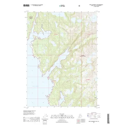
2017 Map of Port Alexander B-3 NW
USGS Topo · Published 2017About this map
Tongass National Forest dominates this coastal landscape on Baranof Island, where the dense southeastern Alaskan wilderness meets the open Gulf of Alaska. The terrain is defined by its deep saltwater inlets and a series of freshwater bodies including Maksoutof Lake and Antipatr Lake in the north, and Tumakof Lake to the south. The irregular coastline is carved by Snipe Bay, Sandy Bay, and Byron Bay, illustrating the complex glacial geography of the Sitka region. This survey captures a roadless environment shaped entirely by its hydrology and elevation, where maritime and mountain ecosystems converge without the footprint of established settlements. It serves as a clear record of the intricate shoreline and drainage patterns within the Alexander Archipelago before modern climate-driven changes significantly alter these coastal boundaries.
Find a feature on this map
14 named features on this map. Tap any name to fly to it.
Don’t see what you’re looking for? This feature index may not catch every label — zoom into the map to look around manually.
Map Details
Editions of this 2017 Port Alexander B-3 NW Map
This is the sole edition of this map. No revisions or reprints were ever made.
Other maps of this area

1951 · Port Alexander C-4
USGS Topo · 1:63,360

1951 · Port Alexander B-3 and B-4
USGS Topo · 1:63,360

1951 · Port Alexander C-3
USGS Topo · 1:63,360

1951 · Port Alexander
USGS Topo · 1:250,000

1952 · Port Alexander
USGS Topo · 1:250,000

1964 · Port Alexander
USGS Topo · 1:250,000

1994 · Port Alexander C-3
USGS Topo · 1:63,360

1994 · Port Alexander C-4
USGS Topo · 1:63,360
2017 · Port Alexander B-4 NE
USGS Topo · 1:25,000
2017 · Port Alexander C-4 SE
USGS Topo · 1:25,000