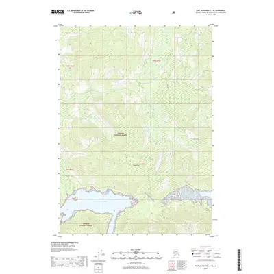
2017 Map of Port Alexander C-1 NE
USGS Topo · Published 2017About this map
Tongass National Forest dominates this coastal portion of Alexander Archipelago, where the landscape is defined by the steep elevation changes and dense drainage networks typical of southeastern Alaska. The map centers on the upper reaches of Kadake Creek, which flows through a complex system of marshlands and small bodies of water like Beaver Pond. At the southern edge, the terrain meets the Gulf of Alaska, revealing a jagged shoreline. Significant for transportation history in this wilderness, the Bay of Pillars-Portage Trail and the Kuiu Mainline provide terrestrial routes through the dense forest, likely serving logging or resource management interests. Named peaks such as Hobnail stand as prominent landmarks amidst the numerous unnamed ridges and valleys that characterize this maritime environment in 2017.
Find a feature on this map
13 named features on this map. Tap any name to fly to it.
Don’t see what you’re looking for? This feature index may not catch every label — zoom into the map to look around manually.
Map Details
Editions of this 2017 Port Alexander C-1 NE Map
This is the sole edition of this map. No revisions or reprints were ever made.
Other maps of this area

1948 · Port Alexander C-1
USGS Topo · 1:63,360

1948 · Petersburg D-6
USGS Topo · 1:63,360

1948 · Port Alexander D-1
USGS Topo · 1:63,360

1948 · Petersburg C-6
USGS Topo · 1:63,360

1951 · Port Alexander
USGS Topo · 1:250,000

1951 · Petersburg D-6
USGS Topo · 1:63,360

1951 · Port Alexander C-1
USGS Topo · 1:63,360

1952 · Petersburg
USGS Topo · 1:250,000

1952 · Port Alexander
USGS Topo · 1:250,000

1960 · Petersburg
USGS Topo · 1:250,000