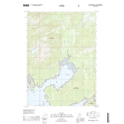
2017 Map of Port Alexander C-1 NW
USGS Topo · Published 2017About this map
Rowan Bay dominates this coastal survey on Kuiu Island, where the intricate shoreline of the Tongass National Forest meets the tides of the Alexander Archipelago. The map documents a landscape defined by its maritime connections, showing the northern reaches of Upper Pillar Bay and the sheltered waters of Upper Rowan Bay. Local identifiers such as Behind Camp and Lost Men provide a window into the localized nomenclature used by foresters or residents in this corner of the Petersburg Borough. The presence of the Kuiu Connection road indicates the vital transport infrastructure supporting land management and accessibility within the densely timbered terrain. This survey provides a precise record of the physical geography and coastal indentation that has historically shaped the fishing and forestry potential of the region.
Find a feature on this map
12 named features on this map. Tap any name to fly to it.
Don’t see what you’re looking for? This feature index may not catch every label — zoom into the map to look around manually.
Map Details
Editions of this 2017 Port Alexander C-1 NW Map
This is the sole edition of this map. No revisions or reprints were ever made.
Other maps of this area

1948 · Port Alexander C-1
USGS Topo · 1:63,360

1948 · Port Alexander D-1
USGS Topo · 1:63,360

1951 · Port Alexander C-2
USGS Topo · 1:63,360

1951 · Port Alexander
USGS Topo · 1:250,000

1951 · Port Alexander D-2
USGS Topo · 1:63,360

1951 · Port Alexander C-1
USGS Topo · 1:63,360

1952 · Port Alexander
USGS Topo · 1:250,000

1964 · Port Alexander
USGS Topo · 1:250,000
1995 · Port Alexander D-2
USGS Topo · 1:63,360
1997 · Port Alexander C-1
USGS Topo · 1:63,360