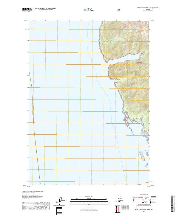
2021 Map of Port Alexander C-2 NE
USGS Topo · Published 2021About this map
Kuiu Island rises from the Pacific waters along the eastern edge of this coastal survey, defined by the protected lands of the Tongass National Forest. The landscape is dominated by the steep, wooded terrain of the Alexander Archipelago, where Washington Bay carves a deep inlet into the western shoreline of the island. This topographic study captures the boundary between the Sitka City and Borough and the Prince of Wales-Hyder Census Area, a line that runs through the open water offshore. To the south, Point Sullivan marks a prominent coastal projection, providing a reference point for maritime navigation through these intricate Southeast Alaska waterways. The map illustrates a largely roadless wilderness where the relationship between the high ridge lines and the complex tidal shoreline remains the primary geographical feature.
Find a feature on this map
9 named features on this map. Tap any name to fly to it.
Don’t see what you’re looking for? This feature index may not catch every label — zoom into the map to look around manually.
Map Details
Editions of this 2021 Port Alexander C-2 NE Map
This is the sole edition of this map. No revisions or reprints were ever made.
Other maps of this area

1948 · Port Alexander C-1
USGS Topo · 1:63,360

1948 · Port Alexander D-1
USGS Topo · 1:63,360

1951 · Port Alexander C-2
USGS Topo · 1:63,360

1951 · Port Alexander
USGS Topo · 1:250,000

1951 · Port Alexander D-2
USGS Topo · 1:63,360

1951 · Port Alexander C-1
USGS Topo · 1:63,360

1952 · Port Alexander
USGS Topo · 1:250,000

1964 · Port Alexander
USGS Topo · 1:250,000
1995 · Port Alexander D-2
USGS Topo · 1:63,360
1997 · Port Alexander C-1
USGS Topo · 1:63,360