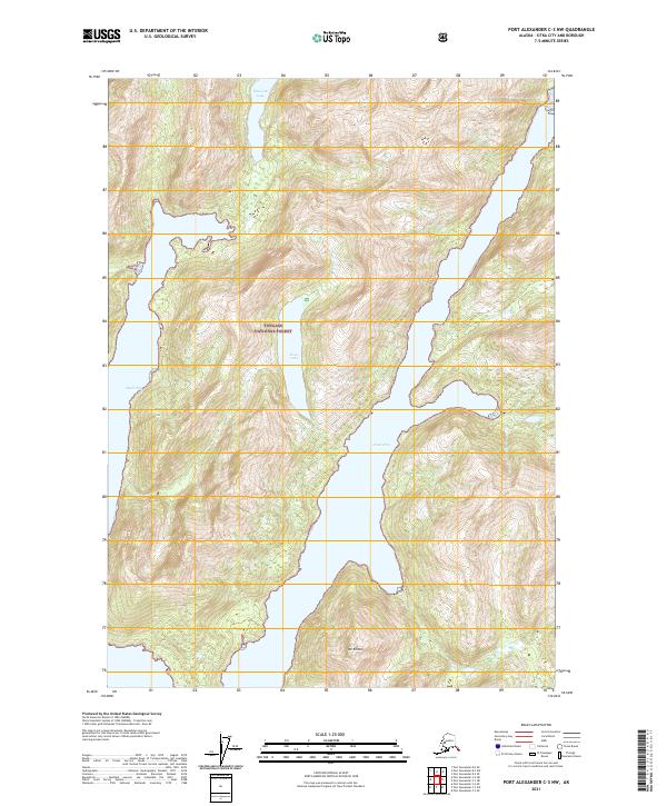
2021 Map of Port Alexander C-3 NW
USGS Topo · Published 2021About this map
Tongass National Forest encloses this secluded maritime landscape on Baranof Island, where steep coastal ridges give way to narrow saltwater inlets. The terrain is defined by the deep indentations of the Great Arm and Small Arm, which reach into the island interior and create a complex shoreline accessible only by water. This high-resolution topographic study captures the freshwater systems that drain these slopes, most notably Politofski Lake in the north and Avoss Lake further south. Rising above the western shore of the Great Arm, Mt Emma serves as a prominent landmark in a region characterized by its lack of roads or permanent settlements. The map illustrates the extreme verticality of the Southeast Alaska coastline, where glacial activity has carved deep basins and high peaks within a dense temperate rainforest environment.
Find a feature on this map
10 named features on this map. Tap any name to fly to it.
Don’t see what you’re looking for? This feature index may not catch every label — zoom into the map to look around manually.
Map Details
Editions of this 2021 Port Alexander C-3 NW Map
This is the sole edition of this map. No revisions or reprints were ever made.
Other maps of this area

1951 · Port Alexander C-4
USGS Topo · 1:63,360

1951 · Port Alexander D-4
USGS Topo · 1:63,360

1951 · Port Alexander C-3
USGS Topo · 1:63,360

1951 · Port Alexander D-3
USGS Topo · 1:63,360

1951 · Port Alexander
USGS Topo · 1:250,000

1952 · Port Alexander
USGS Topo · 1:250,000

1964 · Port Alexander
USGS Topo · 1:250,000

1994 · Port Alexander C-3
USGS Topo · 1:63,360

1994 · Port Alexander C-4
USGS Topo · 1:63,360
1995 · Port Alexander D-3
USGS Topo · 1:63,360