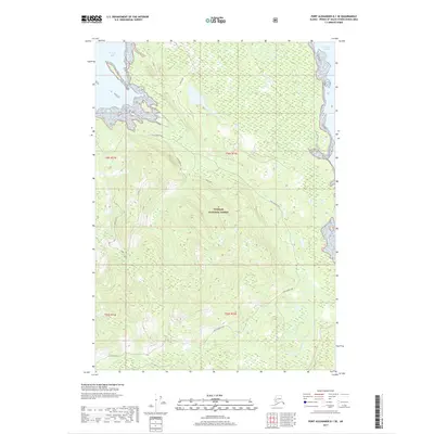
2017 Map of Port Alexander D-1 SE
USGS Topo · Published 2017About this map
Tongass National Forest dominates this coastal landscape on Kuiu Island, where steep terrain and dense maritime forests meet the complex shoreline of Southeast Alaska. The map traces the essential Kuiu Connection, a vital corridor for movement across this portion of the Alexander Archipelago. Along the northern and eastern fringes, the cold waters of Saginaw Bay and Frederick Sound define the geography, while to the south, Kadake Bay and Kadake Creek create a distinct coastal drainage system. Notable landmarks such as Arny's Slide and Ridge Top offer insight into the local nomenclature used by foresters and coastal navigators. This 2017 survey reflects the modern management of these timberlands, highlighting the established network of resource roads and the preservation of coastal watersheds within the nation's largest national forest.
Find a feature on this map
18 named features on this map. Tap any name to fly to it.
Don’t see what you’re looking for? This feature index may not catch every label — zoom into the map to look around manually.
Map Details
Editions of this 2017 Port Alexander D-1 SE Map
This is the sole edition of this map. No revisions or reprints were ever made.
Other maps of this area

1948 · Port Alexander C-1
USGS Topo · 1:63,360

1948 · Petersburg D-6
USGS Topo · 1:63,360

1948 · Port Alexander D-1
USGS Topo · 1:63,360

1948 · Petersburg C-6
USGS Topo · 1:63,360

1951 · Port Alexander
USGS Topo · 1:250,000

1951 · Petersburg D-6
USGS Topo · 1:63,360

1951 · Port Alexander C-1
USGS Topo · 1:63,360

1952 · Petersburg
USGS Topo · 1:250,000

1952 · Port Alexander
USGS Topo · 1:250,000

1960 · Petersburg
USGS Topo · 1:250,000