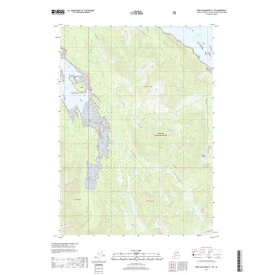
2017 Map of Port Alexander D-1 SW
USGS Topo · Published 2017About this map
Kuiu Island within the Tongass National Forest presents a landscape defined by its deep coastal indentations and forest management routes. In this 2017 survey of the Petersburg Borough, the coastline is marked by the protected waters of Saginaw Bay to the northeast and Security Bay to the west, separated by the prominent Security Ridge. This map provides a detailed view of the modern forestry infrastructure, showing a network of named connector roads such as the Security Bay Connection and Kuiu Connection. Settlement is concentrated at Saginaw Camp, a site linked to the region's timber industry. Freshwater features like Coal Lake and Cool Lake sit high above the shoreline, while numerous drainages including Dean Creek and Saginaw Cr flow toward the coast. Landmarks like Expedition Point and Cedar Bight serve as navigational aids along the irregular Pacific shoreline.
Find a feature on this map
27 named features on this map. Tap any name to fly to it.
Don’t see what you’re looking for? This feature index may not catch every label — zoom into the map to look around manually.
Map Details
Editions of this 2017 Port Alexander D-1 SW Map
This is the sole edition of this map. No revisions or reprints were ever made.
Other maps of this area

1948 · Port Alexander C-1
USGS Topo · 1:63,360

1948 · Port Alexander D-1
USGS Topo · 1:63,360

1951 · Port Alexander C-2
USGS Topo · 1:63,360

1951 · Port Alexander
USGS Topo · 1:250,000

1951 · Port Alexander D-2
USGS Topo · 1:63,360

1951 · Port Alexander C-1
USGS Topo · 1:63,360

1952 · Port Alexander
USGS Topo · 1:250,000

1964 · Port Alexander
USGS Topo · 1:250,000
1995 · Port Alexander D-2
USGS Topo · 1:63,360
1997 · Port Alexander C-1
USGS Topo · 1:63,360