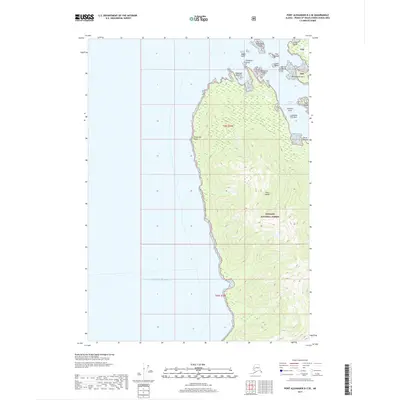
2017 Map of Port Alexander D-2 SE
USGS Topo · Published 2017About this map
Kuiu Island dominates this coastal survey, where the dense wilderness of the Tongass National Forest meets the eastern edge of the Gulf of Alaska. The landscape is defined by a series of evocative maritime landmarks along the northern shoreline, including Retaliation Point, Paralysis Point, and the narrow waters of Band Cove. These names suggest a history of difficult navigation and early seafaring encounters in the Alexander Archipelago. To the northeast, the map transitions into the sheltered waters of Security Bay, protected by a cluster of small islands such as Christmas Island, Harbor Island, and Cleft Island. Offshore hazards like Stewart Rock and Indian Rock underscore the navigational complexity of this remote Alaskan terrain. The topography consists of steep, forested ridges and isolated peaks like Point Lookout, providing a detailed look at the island's natural defensive profile and undeveloped coastline.
Find a feature on this map
23 named features on this map. Tap any name to fly to it.
Don’t see what you’re looking for? This feature index may not catch every label — zoom into the map to look around manually.
Map Details
Editions of this 2017 Port Alexander D-2 SE Map
This is the sole edition of this map. No revisions or reprints were ever made.
Other maps of this area

1948 · Port Alexander C-1
USGS Topo · 1:63,360

1948 · Port Alexander D-1
USGS Topo · 1:63,360

1951 · Port Alexander C-2
USGS Topo · 1:63,360

1951 · Port Alexander
USGS Topo · 1:250,000

1951 · Port Alexander D-2
USGS Topo · 1:63,360

1951 · Port Alexander C-1
USGS Topo · 1:63,360

1952 · Port Alexander
USGS Topo · 1:250,000

1964 · Port Alexander
USGS Topo · 1:250,000
1995 · Port Alexander D-2
USGS Topo · 1:63,360
1997 · Port Alexander C-1
USGS Topo · 1:63,360