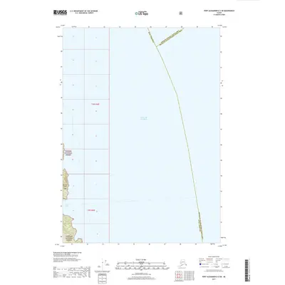
2017 Map of Port Alexander D-2 SW
USGS Topo · Published 2017About this map
The Gulf of Alaska dominates this 2017 survey, meeting the rugged shoreline of Baranof Island along the map's western edge. This coastal interface is part of the expansive Tongass National Forest, where the terrain rises sharply from the sea into the temperate rainforest. The map details the mouth of Hoggatt Bay, providing a clear view of the complex hydrography and nautical approaches to this portion of the Alexander Archipelago. Political and administrative boundaries are a primary focus, illustrating the convergence of the Sitka Borough, the Hoonah-Angoon Census Area, and the Prince of Wales-Hyder Census Area across the open water and forest lands. These jurisdictional lines reflect the complicated management of Alaska's maritime and wilderness regions.
Find a feature on this map
10 named features on this map. Tap any name to fly to it.
Don’t see what you’re looking for? This feature index may not catch every label — zoom into the map to look around manually.
Map Details
Editions of this 2017 Port Alexander D-2 SW Map
This is the sole edition of this map. No revisions or reprints were ever made.
Other maps of this area

1951 · Port Alexander C-2
USGS Topo · 1:63,360

1951 · Port Alexander C-3
USGS Topo · 1:63,360

1951 · Port Alexander D-3
USGS Topo · 1:63,360

1951 · Port Alexander
USGS Topo · 1:250,000

1951 · Port Alexander D-2
USGS Topo · 1:63,360

1952 · Port Alexander
USGS Topo · 1:250,000

1964 · Port Alexander
USGS Topo · 1:250,000

1994 · Port Alexander C-3
USGS Topo · 1:63,360
1995 · Port Alexander D-3
USGS Topo · 1:63,360
1995 · Port Alexander D-2
USGS Topo · 1:63,360