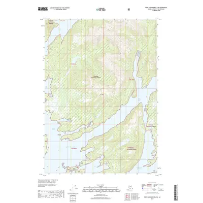
2017 Map of Port Alexander D-4 SW
USGS Topo · Published 2017About this map
Redoubt Lake and the towering heights of Mt Sharp define this coastal stretch of the Tongass National Forest in Southeast Alaska. The map details a complex maritime landscape where the Gulf of Alaska meets a deeply indented shoreline of protected coves and narrow channels. Significant water features like West Crawfish Inlet and Windy Passage separate the mainland from prominent landforms such as Lodge Island and the Rakof Islands. The terrain is characterized by steep elevation changes, rising from the tidal flats of Marsh Bay and Big Bay to the peaks of Camel Mtn. Navigational passages such as Cedar Pass and the First Narrows highlight the intricate coastal geography that has long dictated movement through these Alexander Archipelago waters.
Find a feature on this map
20 named features on this map. Tap any name to fly to it.
Don’t see what you’re looking for? This feature index may not catch every label — zoom into the map to look around manually.
Map Details
Editions of this 2017 Port Alexander D-4 SW Map
This is the sole edition of this map. No revisions or reprints were ever made.
Other maps of this area

1951 · Port Alexander D-5
USGS Topo · 1:63,360

1951 · Port Alexander C-4
USGS Topo · 1:63,360

1951 · Port Alexander D-4
USGS Topo · 1:63,360

1951 · Port Alexander
USGS Topo · 1:250,000

1952 · Port Alexander
USGS Topo · 1:250,000

1964 · Port Alexander
USGS Topo · 1:250,000

1994 · Port Alexander C-4
USGS Topo · 1:63,360
2017 · Port Alexander D-4 NW
USGS Topo · 1:25,000
2017 · Port Alexander D-4 NE
USGS Topo · 1:25,000
2017 · Port Alexander D-4 SE
USGS Topo · 1:25,000