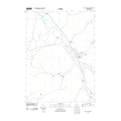
2010 Map of Port Allegany
USGS Topo · Published 2010About this map
Port Allegany serves as the focal point of this northern Pennsylvania landscape, situated where the Allegheny River winds through a series of narrow valleys and named hollows. The river's path is shadowed by significant local infrastructure, including the Allegheny Portage Creek and historical transit routes like Stagecoach Rd. For genealogists and local historians, the area is well-documented through its burial grounds, such as Saint Gabriels Cemetery, Fairview Cemetery, and Lewis Hill Cemetery. To the north, the small settlement of Turtlepoint sits near the confluence of Annin Creek. The southern portion of the quadrangle reflects the region's industrial character, dominated by the Colegrove Gas and Oil Field and specialized transport sites like Johnsons Private Airport. Numerous named geographical features like Steel Hollow and Bemis Hollow suggest a long history of family-named landholdings in the McKean County backcountry.
Find a feature on this map
36 named features on this map. Tap any name to fly to it.
Don’t see what you’re looking for? This feature index may not catch every label — zoom into the map to look around manually.
Map Details
Editions of this 2010 Port Allegany Map
This is the sole edition of this map. No revisions or reprints were ever made.
Other maps of this area

1933 · Smethport
USGS Topo · 1:62,500

1934 · Coudersport
USGS Topo · 1:48,000

1937 · Smethport
USGS Topo · 1:62,500

1938 · Coudersport
USGS Topo · 1:62,500

1948 · Crosby
USGS Topo · 1:62,500

1948 · Emporium
USGS Topo · 1:62,500

1948 · Keating Summit
USGS Topo · 1:24,000

1948 · Norwich
USGS Topo · 1:24,000
1948 · Crosby
USGS Topo · 1:24,000
1950 · Norwich
USGS Topo · 1:24,000