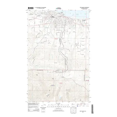
2014 Map of Port Angeles
USGS Topo · Published 2014About this map
Port Angeles anchors the northern coastline of the Olympic Peninsula on this 2014 survey, where the Port Angeles Ferry Landing and Port Angeles City Pier facilitate maritime transit across the Strait of Juan de Fuca. The city's grid transitions from waterfront commerce to residential neighborhoods and educational hubs like Peninsula Coll before rising into the northern reaches of Olympic National Park. This transition from sea level to the high ridges of the Olympic Mountains is marked by the steep drainages of Tumwater Cr, Valley Cr, and Ennis Cr, which carve deep paths through The Foothills. In the southern portion of the map, the terrain rises sharply toward Wildcat Mtn and Lake Angeles, illustrating the literal threshold between urban development and the protected wilderness of the Olympic National Forest.
Find a feature on this map
159 named features on this map. Tap any name to fly to it.
Don’t see what you’re looking for? This feature index may not catch every label — zoom into the map to look around manually.
Map Details
Editions of this 2014 Port Angeles Map
This is the sole edition of this map. No revisions or reprints were ever made.
Other maps of this area

1918 · Port Angeles
USGS Topo · 1:62,500

1919 · Port Crescent
USGS Topo · 1:62,500

1935 · Mount Olympus
USGS Topo · 1:62,500

1938 · Mt Constance
USGS Topo · 1:125,000

1941 · Port Angeles
USGS Topo · 1:62,500

1942 · Mount Olympus
USGS Topo · 1:62,500

1944 · Mt. Angeles
USGS Topo · 1:62,500

1946 · Mt. Angeles
USGS Topo · 1:62,500

1950 · Elwha
USGS Topo · 1:24,000

1950 · Ediz Hook
USGS Topo · 1:24,000