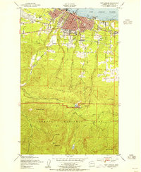
1950 Map of Port Angeles
USGS Topo · Published 1955About this map
Port Angeles serves as the gateway to the mountains in this mid-century survey, positioned where the industrial waterfront of Port Angeles Harbor meets the rising elevations of The Foothills. The city's grid is dense with residential and civic infrastructure, including Lincoln Sch and the expansive Lincoln Park, while the Chicago Milwaukee St Paul and Pacific railroad tracks trace the northern shoreline. South of the city, the landscape transitions rapidly from suburban edges near the Substation and Peninsula Golf Course into the protected wilderness of Olympic National Park. This transition is marked by the Heart of the Hills Ranger Station, which provides a waypoint for those ascending toward high-altitude landmarks like Lake Angeles and First Top. The map captures a moment when timber-era industrialism and early tourism infrastructure coexisted along the Strait of Juan de Fuca.
Find a feature on this map
36 named features on this map. Tap any name to fly to it.
Don’t see what you’re looking for? This feature index may not catch every label — zoom into the map to look around manually.
Map Details
Editions of this 1950 Port Angeles Map
This is the sole edition of this map. No revisions or reprints were ever made.
Other maps of this area

1918 · Port Angeles
USGS Topo · 1:62,500

1919 · Port Crescent
USGS Topo · 1:62,500

1935 · Mount Olympus
USGS Topo · 1:62,500

1938 · Mt Constance
USGS Topo · 1:125,000

1941 · Port Angeles
USGS Topo · 1:62,500

1942 · Mount Olympus
USGS Topo · 1:62,500

1944 · Mt. Angeles
USGS Topo · 1:62,500

1946 · Mt. Angeles
USGS Topo · 1:62,500

1950 · Elwha
USGS Topo · 1:24,000

1950 · Ediz Hook
USGS Topo · 1:24,000