1958 Map of Port Arthur
USGS Topo · Published 1958About this map
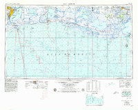
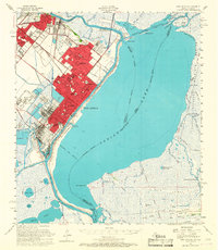
The Port Arthur industrial hub and the vast coastal marshes of the Gulf Coast define this late-1950s regional landscape. Transitioning from the petroleum-rich centers of Port Neches, Nederland, and Groves, the map follows the Texas-Louisiana border through a complex network of bayous and cheniers. The presence of numerous Oil and gas operations and pumping stations underscores the era's energy expansion, while the Intracoastal Waterway serves as a critical artery for maritime transport. Further east, the terrain becomes a wilderness of conservation, dominated by the Sabine Lake Migratory Waterfowl Refuge and the Rockefeller Wild Life Refuge and Game Preserve. High ground is found along ancient ridges such as Pumpkin Ridge and Grand Cheniere Ridge, where small settlements like Pecan Island and Creole established a foothold between the marsh and the sea.
Find a feature on this map
126 named features on this map. Tap any name to fly to it.
Don’t see what you’re looking for? This feature index may not catch every label — zoom into the map to look around manually.
Map Details
Editions of this 1958 Port Arthur Map
This is the sole edition of this map. No revisions or reprints were ever made.
Historical Maps of Port Arthur Through Time
7 maps found