1959 Map of Port Arthur
USGS Topo · Published 1959About this map
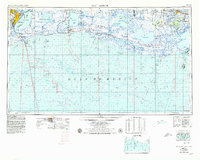
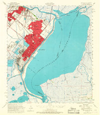
The Gulf Coast's intricate network of bayous, lakes, and industrial waterways dominates this late-1950s survey. Industrial centers like Port Arthur and Port Neches contrast with the expansive wetlands of the Sabine Migratory Waterfowl Refuge and the Rockefeller Wild Life Refuge and Game Preserve. The Intracoastal Waterway cuts a straight line across the marshy landscape, connecting Sabine Lake to Vermilion Bay, facilitating the regional movement of goods. Along the shoreline, small settlements like Holly Beach and Grand Chenier are linked by coastal roads, while the Southern Pacific railroad serves the inland communities. This map reveals a coastline defined by its dual identity as a critical wildlife sanctuary and a hub of maritime commerce, where the Sabine Pass and Calcasieu Pass provide vital access to the Gulf of Mexico.
Find a feature on this map
66 named features on this map. Tap any name to fly to it.
Don’t see what you’re looking for? This feature index may not catch every label — zoom into the map to look around manually.
Map Details
Editions of this 1959 Port Arthur Map
This is the sole edition of this map. No revisions or reprints were ever made.
Historical Maps of Port Arthur Through Time
7 maps found