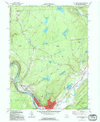
1992 Map of Port Jervis North
USGS Topo · Published 1994About this map
Port Jervis serves as the industrial and transport anchor at the confluence of the Delaware River and the Neversink River, where the borders of New York, Pennsylvania, and New Jersey converge. The city’s historic layout is intricately detailed, featuring the Erie Lackawanna rail lines that once fueled the regional economy. Moving north and west, the landscape shifts toward the high elevations of Buck Knoll and the winding overlooks of Hawks Nest.
Find a feature on this map
61 named features on this map. Tap any name to fly to it.
Don’t see what you’re looking for? This feature index may not catch every label — zoom into the map to look around manually.
Map Details
Editions of this 1992 Port Jervis North Map
This is the sole edition of this map. No revisions or reprints were ever made.
Other maps of this area

1906 · Port Jervis
USGS Topo · 1:62,500

1908 · Port Jervis
USGS Topo · 1:62,500

1909 · Monticello
USGS Topo · 1:62,500

1911 · Monticello
USGS Topo · 1:62,500

1913 · Milford
USGS Topo · 1:62,500

1915 · Milford
USGS Topo · 1:62,500

1922 · White Lake
USGS Topo · 1:62,500

1942 · White Lake
USGS Topo · 1:62,500

1942 · Port Jervis North
USGS Topo · 1:24,000
1942 · Otisville
USGS Topo · 1:24,000