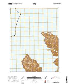
2020 Map of Port Moller A-1 NE
USGS Topo · Published 2020About this map
The Pacific Ocean dominates this coastal survey, where the islands of the Shumagin group meet the open sea. This portion of the archipelago is defined by deep inlets and prominent coastal landmarks, notably Sanborn Harbor and the smaller Cliton Cove on the eastern landmass. These sheltered waters contrast with the exposed passages of the West Nagai Strait. The landscape is characterized by sharp elevations and rocky headlands such as East Head and Macks Head, which provide critical navigational points for vessels moving through the Aleutians. The mapping of Porpoise Harbor highlights a maritime geography where the land is deeply indented by the sea, reflecting a remote environment shaped by volcanic island terrain and the shifting currents of the northern Pacific.
Find a feature on this map
10 named features on this map. Tap any name to fly to it.
Don’t see what you’re looking for? This feature index may not catch every label — zoom into the map to look around manually.
Map Details
Editions of this 2020 Port Moller A-1 NE Map
This is the sole edition of this map. No revisions or reprints were ever made.
Other maps of this area

1951 · Stepovak Bay
USGS Topo · 1:250,000

1953 · Port Moller
USGS Topo · 1:250,000

1963 · Port Moller A-1
USGS Topo · 1:63,360

1963 · Port Moller B-1
USGS Topo · 1:63,360
1963 · Stepovak Bay A-6
USGS Topo · 1:63,360
1963 · Stepovak Bay B-6
USGS Topo · 1:63,360

1963 · Stepovak Bay
USGS Topo · 1:250,000

1969 · Stepovak Bay
USGS Topo · 1:250,000

1988 · Port Moller
USGS Topo · 1:250,000
2020 · Port Moller A-1 NW
USGS Topo · 1:25,000