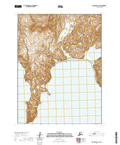
2020 Map of Port Moller A-3 NE
USGS Topo · Published 2020About this map
Unga Island, the largest of the Shumagin Islands in the Aleutians East Borough, dominates this coastal survey. The southern landscape is defined by the deep indentation of Acheredin Bay, which opens into the Pacific Ocean. This 2020 map documents a topography of dramatic elevation changes and a complex shoreline characteristic of the Gulf of Alaska's volcanic island chains. Though uninhabited on this specific quadrangle, the terrain and coastal features provide critical context for the surrounding marine environment and the historical shifts in regional land use within the Aleutian archipelago. The grid lines of townships like t57s r76w and t58s r76w partition the land and sea, indicating the modern administrative structure of this remote Alaskan territory.
Find a feature on this map
8 named features on this map. Tap any name to fly to it.
Don’t see what you’re looking for? This feature index may not catch every label — zoom into the map to look around manually.
Map Details
Editions of this 2020 Port Moller A-3 NE Map
This is the sole edition of this map. No revisions or reprints were ever made.
Other maps of this area

1953 · Port Moller
USGS Topo · 1:250,000

1963 · Port Moller A-2
USGS Topo · 1:63,360

1963 · Port Moller B-2
USGS Topo · 1:63,360
1963 · Port Moller A-3
USGS Topo · 1:63,360

1983 · Port Moller B-3
USGS Topo · 1:63,360

1988 · Port Moller
USGS Topo · 1:250,000
2020 · Port Moller A-2 NW
USGS Topo · 1:25,000
2020 · Port Moller B-3 SE
USGS Topo · 1:25,000
2020 · Port Moller A-2 SW
USGS Topo · 1:25,000
2020 · Port Moller B-2 SW
USGS Topo · 1:25,000