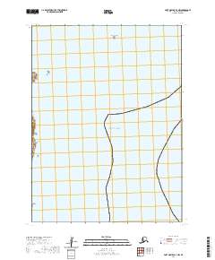
2020 Map of Port Moller A-4 NW
USGS Topo · Published 2020About this map
Wosnesenski Island and the Pavlof Islands group define the western edge of this maritime coastal survey along the Alaska Peninsula. Dominated by the waters of the Pacific Ocean, the map highlights the isolated landforms of the Aleutians East Borough, where rugged shorelines meet the open sea. Further offshore, Omega Island and Clay Island appear as distinct landmarks within the coastal navigation network. The cartography reflects a remote environment defined more by its land-and-sea boundaries than by human settlement, capturing the exact township and range lines established by the Bureau of Land Management for these maritime reaches.
Find a feature on this map
9 named features on this map. Tap any name to fly to it.
Don’t see what you’re looking for? This feature index may not catch every label — zoom into the map to look around manually.
Map Details
Editions of this 2020 Port Moller A-4 NW Map
This is the sole edition of this map. No revisions or reprints were ever made.
Other maps of this area

1953 · Port Moller
USGS Topo · 1:250,000

1963 · Port Moller A-5
USGS Topo · 1:63,360
1963 · Port Moller A-4
USGS Topo · 1:63,360
1983 · Port Moller B-4
USGS Topo · 1:63,360
1983 · Port Moller B-5
USGS Topo · 1:63,360

1988 · Port Moller
USGS Topo · 1:250,000
2020 · Port Moller A-5 SE
USGS Topo · 1:25,000
2020 · Port Moller B-5 SE
USGS Topo · 1:25,000
2020 · Port Moller B-4 SW
USGS Topo · 1:25,000
2020 · Port Moller A-4 NE
USGS Topo · 1:25,000