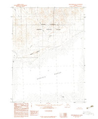
1983 Map of Port Moller B-4
USGS Topo · Published 1983About this map
The Alaska Peninsula shoreline meets the Pacific Ocean in this coastal survey, where the terrestrial landscape is dominated by the Alaska Peninsula National Wildlife Refuge. The terrain is characterized by the prominent rise of Bobrovia Mountain and several drainage systems, including Humpy Creek, Ness Creek, and Mino Creek, which flow toward the southern coast. This 1983 provisional edition captures a wild coastal reach defined by its natural topography rather than human settlement. Notable maritime landmarks include Seal Cape and Jude Island, with extensive Tidal Flats and the protected waters of Coal Bay marking the complex boundary where the land and sea intersect. The map serves as a primary record of the coastal wilderness and hydrological patterns of the peninsula during the early 1980s.
Find a feature on this map
13 named features on this map. Tap any name to fly to it.
Don’t see what you’re looking for? This feature index may not catch every label — zoom into the map to look around manually.
Map Details
Editions of this 1983 Port Moller B-4 Map
This is the sole edition of this map. No revisions or reprints were ever made.
Other maps of this area

1953 · Port Moller
USGS Topo · 1:250,000

1963 · Port Moller A-5
USGS Topo · 1:63,360
1963 · Port Moller A-4
USGS Topo · 1:63,360

1963 · Port Moller C-5
USGS Topo · 1:63,360
1963 · Port Moller A-3
USGS Topo · 1:63,360

1983 · Port Moller B-3
USGS Topo · 1:63,360

1983 · Port Moller C-4
USGS Topo · 1:63,360

1983 · Port Moller C-3
USGS Topo · 1:63,360
1983 · Port Moller B-5
USGS Topo · 1:63,360

1988 · Port Moller
USGS Topo · 1:250,000