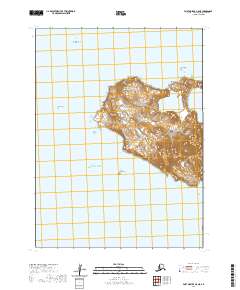
2020 Map of Port Moller A-5 NE
USGS Topo · Published 2020About this map
Wosnesenski Island dominates this maritime survey, rising from the Pacific Ocean within the Aleutians East Borough. The terrain is defined by its isolation and several prominent coastal and offshore landmarks. To the north, Ukolnoi Rocks and Egg Island mark the waters of the Bering Sea approaches, while Midway Rock sits to the west. On the island itself, topographic contours reveal significant elevations, peaking at The Pinnacle and sloping down toward Southwest Point. This 2020 edition provides a contemporary look at these uninhabited landforms, illustrating the complex shoreline and surrounding hazards that characterize this part of the Alaska Peninsula region.
Find a feature on this map
12 named features on this map. Tap any name to fly to it.
Don’t see what you’re looking for? This feature index may not catch every label — zoom into the map to look around manually.
Map Details
Editions of this 2020 Port Moller A-5 NE Map
This is the sole edition of this map. No revisions or reprints were ever made.
Other maps of this area

1953 · Port Moller
USGS Topo · 1:250,000

1963 · Port Moller A-5
USGS Topo · 1:63,360
1963 · Port Moller A-4
USGS Topo · 1:63,360
1983 · Port Moller B-4
USGS Topo · 1:63,360
1983 · Port Moller B-5
USGS Topo · 1:63,360

1988 · Port Moller
USGS Topo · 1:250,000
2020 · Port Moller A-5 SE
USGS Topo · 1:25,000
2020 · Port Moller A-5 NW
USGS Topo · 1:25,000
2020 · Port Moller B-5 SE
USGS Topo · 1:25,000
2020 · Port Moller B-4 SW
USGS Topo · 1:25,000