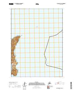
2020 Map of Port Moller B-1 NE
USGS Topo · Published 2020About this map
Cape Devine and the coastal features of the Aleutians East Borough define this remote maritime landscape along the Pacific Ocean. This survey reveals the stark intersection of the sea with the volcanic topography of the Alaskan Peninsula, where Scotland Point serves as a prominent landform marking the western shoreline. Offshore, the isolated position of Scotland Rock underscores the navigational hazards inherent to this stretch of coast.
Find a feature on this map
7 named features on this map. Tap any name to fly to it.
Don’t see what you’re looking for? This feature index may not catch every label — zoom into the map to look around manually.
Map Details
Editions of this 2020 Port Moller B-1 NE Map
This is the sole edition of this map. No revisions or reprints were ever made.
Other maps of this area

1951 · Stepovak Bay
USGS Topo · 1:250,000

1953 · Port Moller
USGS Topo · 1:250,000

1963 · Port Moller B-1
USGS Topo · 1:63,360

1963 · Port Moller C-1
USGS Topo · 1:63,360
1963 · Stepovak Bay B-6
USGS Topo · 1:63,360

1963 · Stepovak Bay
USGS Topo · 1:250,000

1969 · Stepovak Bay
USGS Topo · 1:250,000

1988 · Port Moller
USGS Topo · 1:250,000
2020 · Port Moller C-1 SE
USGS Topo · 1:25,000
2020 · Stepovak Bay B-6 SW
USGS Topo · 1:25,000