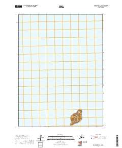
2020 Map of Port Moller C-1 SE
USGS Topo · Published 2020About this map
Karpa Island rises from the maritime waters of the Shumagin Islands in this topographic study of the Alaska Peninsula region. Located within the Aleutians East Borough, the landform is defined by distinct elevation contours that reach a central peak, illustrating the steep coastal topography characteristic of this archipelago. The surrounding expanse is primarily maritime, divided by the Public Land Survey System grid lines for t54s r71w and t54s r70w. This survey is focused on the uninhabited landmass, providing a clear record of the shoreline and elevation before further natural or environmental shifts. It serves as a specific reference for the geographic boundaries and hydrography of this isolated portion of the Shumagin group.
Find a feature on this map
4 named features on this map. Tap any name to fly to it.
Don’t see what you’re looking for? This feature index may not catch every label — zoom into the map to look around manually.
Map Details
Editions of this 2020 Port Moller C-1 SE Map
This is the sole edition of this map. No revisions or reprints were ever made.
Other maps of this area

1951 · Stepovak Bay
USGS Topo · 1:250,000

1953 · Port Moller
USGS Topo · 1:250,000

1963 · Port Moller B-1
USGS Topo · 1:63,360

1963 · Port Moller C-1
USGS Topo · 1:63,360
1963 · Stepovak Bay B-6
USGS Topo · 1:63,360

1963 · Stepovak Bay
USGS Topo · 1:250,000

1969 · Stepovak Bay
USGS Topo · 1:250,000

1988 · Port Moller
USGS Topo · 1:250,000
2020 · Port Moller C-1 NW
USGS Topo · 1:25,000
2020 · Port Moller B-1 NW
USGS Topo · 1:25,000