2020 Map of Stepovak Bay B-6 SW
USGS Topo · Published 2020About this map
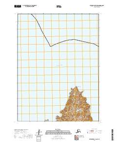
Nagai Island, a primary landmass within the Shumagin Islands chain, dominates the southern portion of this maritime survey. The island's northern tip is defined by the prominent Cape Wedge, which juts into the open Pacific Ocean. To the west, the waters of the West Nagai Strait separate the island from adjacent landmasses. The map illustrates the complex topography of the island's interior, featuring steep elevation changes and coastal indentations. This modern survey reflects the enduring geography of the Aleutians East region, where navigation and coastal landforms remain the primary markers of the landscape. The lack of terrestrial infrastructure highlights the wilderness character of the Shumagin group, preserving a view of the islands as they exist for maritime passage and conservation today.
Find a feature on this map
10 named features on this map. Tap any name to fly to it.
Don’t see what you’re looking for? This feature index may not catch every label — zoom into the map to look around manually.
Map Details
Editions of this 2020 Stepovak Bay B-6 SW Map
This is the sole edition of this map. No revisions or reprints were ever made.
Other maps of this area

1951 · Stepovak Bay
USGS Topo · 1:250,000

1953 · Port Moller
USGS Topo · 1:250,000

1963 · Port Moller A-1
USGS Topo · 1:63,360

1963 · Port Moller B-1
USGS Topo · 1:63,360
1963 · Stepovak Bay A-6
USGS Topo · 1:63,360
1963 · Stepovak Bay B-6
USGS Topo · 1:63,360

1963 · Stepovak Bay
USGS Topo · 1:250,000

1969 · Stepovak Bay
USGS Topo · 1:250,000

1988 · Port Moller
USGS Topo · 1:250,000
2020 · Stepovak Bay A-6 NW
USGS Topo · 1:25,000