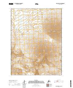
2020 Map of Port Moller B-6 NW
USGS Topo · Published 2020About this map
Pavlof Volcano dominates this section of the Alaska Peninsula, its massive conical form defining the local topography. This 2020 survey illustrates the stark volcanic landscape of the Aleutians East Borough, where the high peaks of Pavlof Sister and Little Pavlof stand in close proximity to the main crater. To the southwest, Mt Hague adds to the cluster of active geothermal features that characterize this segment of the Pacific Ring of Fire. The drainage patterns on the lower slopes are carved by the Caribou River, which flows through the northern reaches of the quadrangle. The map provides a precise view of these geological landmarks as they appeared in the early 21st century, showing the intricate contouring of the volcanic vents and the remote glacial and riverine systems surrounding them.
Find a feature on this map
9 named features on this map. Tap any name to fly to it.
Don’t see what you’re looking for? This feature index may not catch every label — zoom into the map to look around manually.
Map Details
Editions of this 2020 Port Moller B-6 NW Map
This is the sole edition of this map. No revisions or reprints were ever made.
Other maps of this area

1943 · Fort Randall
USGS Topo · 1:250,000

1949 · Fort Randall
USGS Topo · 1:250,000

1950 · Fort Randall
USGS Topo · 1:250,000

1953 · Port Moller
USGS Topo · 1:250,000

1963 · Port Moller C-6
USGS Topo · 1:63,360
1963 · Cold Bay C-1
USGS Topo · 1:63,360

1983 · Port Moller B-6
USGS Topo · 1:63,360
1983 · Cold Bay B-1
USGS Topo · 1:63,360

1988 · Port Moller
USGS Topo · 1:250,000
2020 · Cold Bay B-1 NE
USGS Topo · 1:25,000