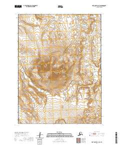
2020 Map of Port Moller C-6 SW
USGS Topo · Published 2020About this map
Trader Mtn rises as a central landmark within the Aleutian Range on the Alaska Peninsula. This 2020 survey illustrates a landscape dominated by glacial and volcanic topography where drainage patterns define the geography. To the south of the mountain, Divide Lake sits near the township boundary between T53S and T54S, acting as a hydrologic marker in this wilderness area. The drainage network is characterized by several significant watercourses, including the Steelhead Cr which flows northward, and the David River and Caribou River which navigate the eastern reaches of the quadrangle. The map captures a moment in the modern era where the land remains largely defined by its natural features and surveying lines rather than human infrastructure, making it a clear record of the peninsula's coastal mountain character.
Find a feature on this map
10 named features on this map. Tap any name to fly to it.
Don’t see what you’re looking for? This feature index may not catch every label — zoom into the map to look around manually.
Map Details
Editions of this 2020 Port Moller C-6 SW Map
This is the sole edition of this map. No revisions or reprints were ever made.
Other maps of this area

1943 · Fort Randall
USGS Topo · 1:250,000

1949 · Fort Randall
USGS Topo · 1:250,000

1950 · Fort Randall
USGS Topo · 1:250,000

1953 · Port Moller
USGS Topo · 1:250,000

1963 · Port Moller C-6
USGS Topo · 1:63,360
1963 · Cold Bay C-1
USGS Topo · 1:63,360

1983 · Port Moller B-6
USGS Topo · 1:63,360
1983 · Cold Bay B-1
USGS Topo · 1:63,360

1988 · Port Moller
USGS Topo · 1:250,000
2020 · Cold Bay C-1 NE
USGS Topo · 1:25,000