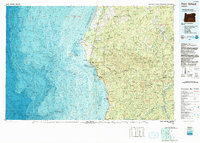
1992 Map of Port Orford
USGS Topo · Published 1993About this map
Cape Blanco and the rugged coastline of southern Oregon define this 1993 topographic-bathymetric study, which details the interface between the Pacific Ocean and the coastal ranges of Curry and Coos counties. The map illustrates a landscape shaped by significant drainages, including the Sixes River, Elk River, and the southern reach of the Rogue River as it nears the sea. While the coastal corridor is connected by Highway 101 and small settlements like Langlois and Port Orford, the interior quickly rises into the protected reaches of the Siskiyou National Forest and Grassy Knob Wilderness. This dual-purpose map is particularly valuable for its bathymetric data, showing the complex underwater contours and reefs offshore, such as the Oregon Islands National Wildlife Refuge, providing a rare look at both the terrestrial peaks like Iron Mountain and the deep maritime environment simultaneously.
Find a feature on this map
43 named features on this map. Tap any name to fly to it.
Don’t see what you’re looking for? This feature index may not catch every label — zoom into the map to look around manually.
Map Details
Editions of this 1992 Port Orford Map
This is the sole edition of this map. No revisions or reprints were ever made.
Other maps of this area

1896 · Coos Bay
USGS Topo · 1:125,000

1898 · Coos Bay
USGS Topo · 1:125,000

1899 · Port Orford
USGS Topo · 1:125,000

1900 · Coos Bay
USGS Topo · 1:125,000

1903 · Port Orford
USGS Topo · 1:125,000

1917 · Kerby
USGS Topo · 1:125,000

1918 · Kerby
USGS Topo · 1:125,000

1928 · Sitkum
USGS Topo · 1:125,000

1942 · Coquille
USGS Topo · 1:62,500

1943 · Bandon
USGS Topo · 1:62,500