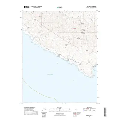
2018 Map of Port San Luis
USGS Topo · Published 2018About this map
The Irish Hills dominate this coastal landscape of San Luis Obispo County, where steep-walled drainages such as Ruda Canyon and Diablo Canyon carve through the uplifted terrain toward the Pacific Ocean. This survey reveals a complex network of coastal access and industrial history, particularly through the labeling of Diablo Canyon Mine Canyon and the winding Pecho Valley Rd. The coastline is marked by distinct geological features including Tunnel Point and the sheltering waters of San Luis Obispo Bay. A detailed look at the interior topography shows a series of named canyons like Wild Cherry Canyon and Rattlesnake Canyon that have historically dictated movement through this segment of the Central Coast. The absence of major settlements emphasizes the area's role as a rugged corridor of utility and natural landforms, punctuated by rural routes such as Coon Creek Rd and Lighthouse Rd.
Find a feature on this map
36 named features on this map. Tap any name to fly to it.
Don’t see what you’re looking for? This feature index may not catch every label — zoom into the map to look around manually.
Map Details
Editions of this 2018 Port San Luis Map
This is the sole edition of this map. No revisions or reprints were ever made.
Other maps of this area

1897 · Port Harford
USGS Topo · 1:62,500

1897 · San Luis Obispo
USGS Topo · 1:62,500

1897 · Cayucos
USGS Topo · 1:62,500

1897 · Arroyo Grande
USGS Topo · 1:62,500

1900 · San Luis
USGS Topo · 1:125,000

1937 · Cayucos
USGS Topo · 1:62,500

1941 · Port San Luis
USGS Topo · 1:62,500

1942 · San Luis Obispo
USGS Topo · 1:62,500

1942 · Arroyo Grande
USGS Topo · 1:62,500

1943 · Cayucos
USGS Topo · 1:62,500