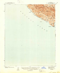
1945 Map of Port San Luis
USGS Topo · Published 1945About this map
The coastal shelf of Central California is defined here by the steep rise of the San Luis Range directly from the Pacific Ocean. This 1939 survey, published just after the war, captures the essential maritime infrastructure of Port San Luis and its connection to the interior via the P C Ry. The coastline is marked by numerous hazards and prominent navigational landmarks, from Lion Rock in the north to the jagged Pt San Luis and the nearby Whaler I.
Find a feature on this map
21 named features on this map. Tap any name to fly to it.
Don’t see what you’re looking for? This feature index may not catch every label — zoom into the map to look around manually.
Map Details
Editions of this 1945 Port San Luis Map
This is the sole edition of this map. No revisions or reprints were ever made.
Other maps of this area

1897 · Port Harford
USGS Topo · 1:62,500

1897 · San Luis Obispo
USGS Topo · 1:62,500

1897 · Cayucos
USGS Topo · 1:62,500

1897 · Arroyo Grande
USGS Topo · 1:62,500

1900 · San Luis
USGS Topo · 1:125,000

1905 · Guadalupe
USGS Topo · 1:125,000

1937 · Cayucos
USGS Topo · 1:62,500

1941 · Port San Luis
USGS Topo · 1:62,500

1942 · Guadalupe
USGS Topo · 1:125,000

1942 · San Luis Obispo
USGS Topo · 1:62,500