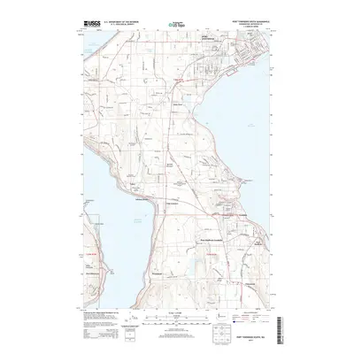
2014 Map of Port Townsend South
USGS Topo · Published 2014About this map
Quimper Peninsula serves as the geographic heart of this coastal survey, where maritime heritage and modern infrastructure meet. The northern edge is anchored by Port Townsend, featuring the vital Port Townsend Ferry Landing and the historical grounds of Laurel Grove Cem. To the south, the landscape transitions into the wooded corridors of the Chimacum Valley, marked by the confluence of Chimacum Cr and the waters of Anderson Lake. Along the eastern shore, developed communities such as Port Hadlock-Irondale and Irondale neighbor the distinct shoreline of Kala Point. The western coast, overlooking Puget Sound, remains less dense, defined by the quiet residential stretches of Adelma Beach and the spiritual grounds of the Discovery Bay Camp Meeting. This survey illustrates the continued importance of regional transit, from the Jefferson County International Airport to the rugged path of the Pacific NW National Scenic Trail.
Find a feature on this map
108 named features on this map. Tap any name to fly to it.
Don’t see what you’re looking for? This feature index may not catch every label — zoom into the map to look around manually.
Map Details
Editions of this 2014 Port Townsend South Map
This is the sole edition of this map. No revisions or reprints were ever made.
Other maps of this area

1937 · Port Gamble
USGS Topo · 1:62,500

1939 · Port Townsend
USGS Topo · 1:62,500

1939 · Coupeville
USGS Topo · 1:62,500

1940 · Port Gamble
USGS Topo · 1:62,500

1940 · Quilcene
USGS Topo · 1:62,500

1953 · Coupeville
USGS Topo · 1:24,000

1953 · Nordland
USGS Topo · 1:24,000

1953 · Center
USGS Topo · 1:24,000
1953 · Port Ludlow
USGS Topo · 1:24,000

1953 · Port Townsend North
USGS Topo · 1:24,000