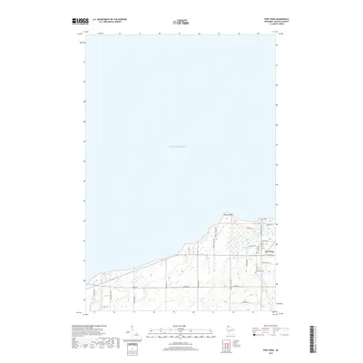
2018 Map of Port Wing
USGS Topo · Published 2018About this map
Lake Superior dominates the northern half of this coastal survey, where the shoreline is punctuated by the prominent Quarry Point. The settlement of Port Wing serves as the primary hub, situated near the eastern edge where a grid of local streets like Grand Ave and 5th St meet the lakefront. South of the village, the Greenwood Cem remains a significant landmark for those tracing local family lineages. The landscape is defined by a network of rural roads, including Landon Rd and Old 13 Rd, which connect inland homesteads to the harbor. To the west, the Iron River flows toward the lake, with Orienta Falls Rd marking the transition into the more wooded interior. The nomenclature of roads like Quarry Rd and Quarry Shores Rd preserves the area's historical connection to stone extraction along the shoreline.
Find a feature on this map
28 named features on this map. Tap any name to fly to it.
Don’t see what you’re looking for? This feature index may not catch every label — zoom into the map to look around manually.
Map Details
Editions of this 2018 Port Wing Map
This is the sole edition of this map. No revisions or reprints were ever made.
Other maps of this area

1943 · Port Wing
USGS Topo · 1:48,000

1943 · Iron Lake
USGS Topo · 1:48,000

1946 · Port Wing
USGS Topo · 1:48,000

1947 · Brule
USGS Topo · 1:48,000

1947 · Iron Lake
USGS Topo · 1:48,000

1953 · Ashland
USGS Topo · 1:250,000

1958 · Ashland
USGS Topo · 1:250,000
1961 · Iron Lake
USGS Topo · 1:62,500
1961 · Port Wing
USGS Topo · 1:62,500
1961 · Brule
USGS Topo · 1:62,500