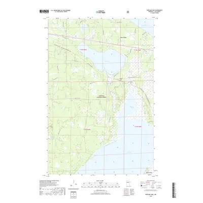
2019 Map of Portage Lake
USGS Topo · Published 2019About this map
Chippewa National Forest dominates this northern Minnesota landscape, where the waters of Leech Lake and Lake Winnibigoshish converge through a network of smaller basins and creeks. Near the southeastern corner, the settlement of Federal Dam marks a critical point of hydrologic control and historical transit. The map reveals a land defined by its recreational and timber heritage, showing an intricate system of forest routes like Forest Rte 3762 and specialized paths such as the Soo Line ATV Trail and the Soo Line GIA Snowmobile Trail. Smaller water bodies like Portage Lake and Bud Lake are tucked into the woods, while Rabbits Cem near Portage Cr provides a specific point of interest for genealogists and local historians tracking early residents of the Ryan Village area.
Find a feature on this map
32 named features on this map. Tap any name to fly to it.
Don’t see what you’re looking for? This feature index may not catch every label — zoom into the map to look around manually.
Map Details
Editions of this 2019 Portage Lake Map
This is the sole edition of this map. No revisions or reprints were ever made.
Other maps of this area

1954 · Bemidji
USGS Topo · 1:250,000

1957 · Bemidji
USGS Topo · 1:250,000

1958 · Bemidji
USGS Topo · 1:250,000

1971 · Raven Lake
USGS Topo · 1:24,000

1971 · Bena
USGS Topo · 1:24,000

1971 · Sucker Lakes
USGS Topo · 1:24,000

1971 · Pennington
USGS Topo · 1:24,000
1971 · Bena NW
USGS Topo · 1:24,000
1971 · Federal Dam
USGS Topo · 1:24,000

1971 · Portage Lake
USGS Topo · 1:24,000