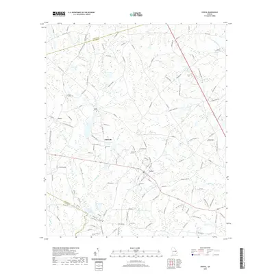
2020 Map of Portal
USGS Topo · Published 2020About this map
The town of Portal serves as the central hub of this South Georgia landscape, where agricultural land meets the winding tributaries of Lotts Cr and Mill Cr. The map details a rural network of small settlements including Piddleville and Aaron, surrounded by family-named ponds and groves that speak to the area's deep-rooted landownership. Notable water features like Parrish Lake, Lake Collins, and East Oglesby Pond are interspersed with several small creeks such as Panther Br and Wyatts Br. Genealogists will find significant value in the numerous recorded burial sites across the Bulloch County countryside, from the Portal Cem near the town center to more secluded locations like the Mincy Cem, Franklin Cem, and Scarboro Grove Cem. The map's layout reflects a transition from traditional farming tracts to a more modern road network, while maintaining the historical placement of churches and cemeteries.
Find a feature on this map
120 named features on this map. Tap any name to fly to it.
Don’t see what you’re looking for? This feature index may not catch every label — zoom into the map to look around manually.
Map Details
Editions of this 2020 Portal Map
This is the sole edition of this map. No revisions or reprints were ever made.
Other maps of this area

1920 · Statesboro
USGS Topo · 1:62,500

1921 · Rocky Ford
USGS Topo · 1:62,500

1943 · Rocky Ford
USGS Topo · 1:62,500

1943 · Millen
USGS Topo · 1:125,000

1943 · Statesboro
USGS Topo · 1:62,500

1947 · Savannah
USGS Topo · 1:250,000

1948 · Savannah
USGS Topo · 1:250,000

1957 · Macon
USGS Topo · 1:250,000

1957 · Savannah
USGS Topo · 1:250,000

1958 · Macon
USGS Topo · 1:250,000