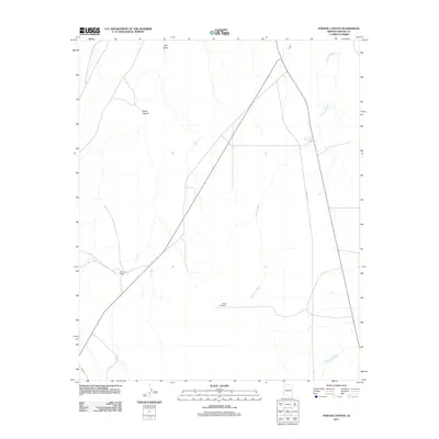
2011 Map of Porter Canyon
USGS Topo · Published 2011About this map
Porter Canyon and the surrounding high desert of Navajo County define this landscape south of Holbrook. This arid environment is characterized by an extensive network of ephemeral drainages, including Fivemile Wash, Washboard Wash, and Tank Draw, which illustrate the complex water management required for ranching in this region. Evidence of local land use is centered on the Jeffers Ranch and the presence of critical infrastructure like the Flake Windmill, Tower Tank, and Five Mile Reservoir. Roadways such as Reidhead Ave and Oasis Trl provide access through the scrubland, connecting isolated points of interest. The map documents a classic Arizona ranching territory where the geography of dry washes and small-scale water improvements dictates the pattern of human presence.
Find a feature on this map
11 named features on this map. Tap any name to fly to it.
Don’t see what you’re looking for? This feature index may not catch every label — zoom into the map to look around manually.
Map Details
Editions of this 2011 Porter Canyon Map
This is the sole edition of this map. No revisions or reprints were ever made.
Other maps of this area

1886 · Holbrook
USGS Topo · 1:250,000

1893 · Holbrook
USGS Topo · 1:250,000

1954 · Holbrook
USGS Topo · 1:250,000

1955 · St. Joseph 1 NE
USGS Topo · 1:24,000

1955 · St. Joseph 2 SE
USGS Topo · 1:24,000

1955 · St. Joseph 1 SE
USGS Topo · 1:24,000

1955 · St. Joseph 1 NW
USGS Topo · 1:24,000
1955 · St. Joseph 2 NE
USGS Topo · 1:24,000

1955 · Joseph City
USGS Topo · 1:62,500
1955 · Holbrook
USGS Topo · 1:62,500