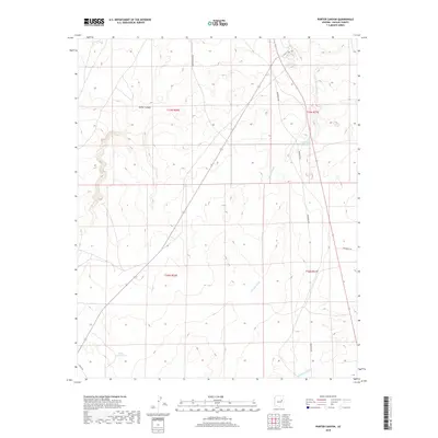
2018 Map of Porter Canyon
USGS Topo · Published 2018About this map
Porter Canyon cuts across the high desert terrain of Navajo County in this modern-era study, defining the natural drainage patterns that have long shaped the landscape south of Holbrook. The map reveals a sparse network of ranching and utility roads, including Reidhead Ave and Porter Canyon Rd, which navigate the subtle changes in elevation. Water management is a central theme of this arid region, as evidenced by the Five Mile Reservoir and specialized features like the Heber Road Tank. These man-made improvements, alongside seasonal watercourses such as Fivvemile Wash and Washboard Wash, illustrate the ongoing effort to capture and direct intermittent rainfall for local use. For the researcher, the map preserves the exact placement of livestock infrastructure and local travel routes like Oasis Trl as they existed during the 2010s.
Find a feature on this map
14 named features on this map. Tap any name to fly to it.
Don’t see what you’re looking for? This feature index may not catch every label — zoom into the map to look around manually.
Map Details
Editions of this 2018 Porter Canyon Map
This is the sole edition of this map. No revisions or reprints were ever made.
Other maps of this area

1886 · Holbrook
USGS Topo · 1:250,000

1893 · Holbrook
USGS Topo · 1:250,000

1954 · Holbrook
USGS Topo · 1:250,000

1955 · St. Joseph 1 NE
USGS Topo · 1:24,000

1955 · St. Joseph 2 SE
USGS Topo · 1:24,000

1955 · St. Joseph 1 SE
USGS Topo · 1:24,000

1955 · St. Joseph 1 NW
USGS Topo · 1:24,000
1955 · St. Joseph 2 NE
USGS Topo · 1:24,000

1955 · Joseph City
USGS Topo · 1:62,500
1955 · Holbrook
USGS Topo · 1:62,500