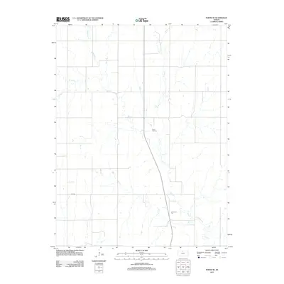
2012 Map of Portis NE
USGS Topo · Published 2012About this map
Oak Creek and its many branches form the primary landscape pattern of this Jewell County region, with Middle Oak Creek, Spring Creek, and East Oak Creek carving a series of north-south drainages through the prairie. The road network follows a strict sectional grid typical of the Great Plains, occasionally interrupted by the winding courses of Buck Creek or the path of County Road 868. Two specific locations provide significant value for family historians: N Oak Creek Cemetery and S Oak Creek Cemetery, which serve as permanent anchors for the rural community in this portion of Kansas. This 2012 survey by the U. S. Geological Survey documents the persistent agricultural character of the land, where the drainage systems of West Oak Creek and its tributaries remain the most prominent natural features amidst the cultivated fields.
Find a feature on this map
9 named features on this map. Tap any name to fly to it.
Don’t see what you’re looking for? This feature index may not catch every label — zoom into the map to look around manually.
Map Details
Editions of this 2012 Portis NE Map
This is the sole edition of this map. No revisions or reprints were ever made.
Other maps of this area

1893 · Smith Center
USGS Topo · 1:125,000

1894 · Mankato
USGS Topo · 1:125,000

1955 · Beloit
USGS Topo · 1:250,000

1959 · Beloit
USGS Topo · 1:250,000

1960 · Downs North
USGS Topo · 1:24,000

1961 · Portis
USGS Topo · 1:24,000

1962 · Cawker City
USGS Topo · 1:24,000
1969 · Cawker City NW
USGS Topo · 1:24,000
1969 · Esbon
USGS Topo · 1:24,000
1973 · Portis NE
USGS Topo · 1:24,000