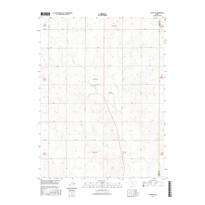
2015 Map of Portis NE
USGS Topo · Published 2015About this map
The boundary between Smith and Jewell Counties defines the eastern edge of this agricultural landscape in north-central Kansas. This 2015 survey illustrates a rural terrain deeply carved by the drainage systems of the Oak Creek watershed. Multiple branches, including Spring Creek, Middle Oak Creek, and East Oak Creek, wind through the land, converging into the primary Oak Creek channel that flows toward the southeast. The survey reveals a grid-based transportation network typical of the Great Plains, where numbered roads like 200 Road and 210 Road provide access to the expansive sections of the Public Land Survey System. Genealogical interest is anchored by the presence of the North Oak Creek Cemetery and South Oak Creek Cemetery, both situated along the central corridor of the township, serving as enduring markers of the area's early settlement history.
Find a feature on this map
30 named features on this map. Tap any name to fly to it.
Don’t see what you’re looking for? This feature index may not catch every label — zoom into the map to look around manually.
Map Details
Editions of this 2015 Portis NE Map
This is the sole edition of this map. No revisions or reprints were ever made.
Other maps of this area

1893 · Smith Center
USGS Topo · 1:125,000

1894 · Mankato
USGS Topo · 1:125,000

1955 · Beloit
USGS Topo · 1:250,000

1959 · Beloit
USGS Topo · 1:250,000

1960 · Downs North
USGS Topo · 1:24,000

1961 · Portis
USGS Topo · 1:24,000

1962 · Cawker City
USGS Topo · 1:24,000
1969 · Cawker City NW
USGS Topo · 1:24,000
1969 · Esbon
USGS Topo · 1:24,000
1973 · Portis NE
USGS Topo · 1:24,000