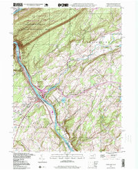
1997 Map of Portland
USGS Topo · Published 1999About this map
The Delaware River cuts a deep path through Kittatinny Mountain here, framing the tri-state border region of Pennsylvania and New Jersey. The river corridor is a hub of transport and industry, featuring a prominent powerplant and the Pennsylvania New Jersey railroad line running parallel to the water. In the valley, the village of Portland sits across from Columbia, while smaller settlements like Hainesburg and Polkville are tucked into the interior hills of New Jersey. The map highlights a landscape preserved for public use, with the Worthington State Forest and the Delaware Water Gap National Recreational Area covering much of the northern terrain. Local history is well-preserved through numerous family and community sites, including Knowlton Frame Cem, Riverview Cem, and the Vail Sch. Several former infrastructure points, such as the Hainesburg Sta, indicate the importance of the rail network to these riverside communities.
Find a feature on this map
63 named features on this map. Tap any name to fly to it.
Don’t see what you’re looking for? This feature index may not catch every label — zoom into the map to look around manually.
Map Details
Editions of this 1997 Portland Map
This is the sole edition of this map. No revisions or reprints were ever made.
Other maps of this area

1888 · Hackettstown
USGS Topo · 1:62,500

1891 · Wallpack
USGS Topo · 1:62,500

1891 · Delaware Water Gap
USGS Topo · 1:62,500

1893 · Delaware Water Gap
USGS Topo · 1:62,500

1893 · Wallpack
USGS Topo · 1:62,500

1894 · Hackettstown
USGS Topo · 1:62,500

1898 · Hackettstown
USGS Topo · 1:62,500

1900 · Raritan
USGS Topo · 1:125,000

1905 · Raritan
USGS Topo · 1:125,000

1905 · Hackettstown
USGS Topo · 1:62,500