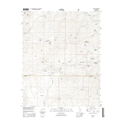
2015 Map of Posey
USGS Topo · Published 2015About this map
Sequoia National Forest dominates the high-elevation landscape of this 2015 study, where the foothills of the Sierra Nevada meet the Tulare and Kern County line. Small residential enclaves and mountain retreats like Posey, Idlewild, and Sugarloaf Village are tucked into the drainages of the White River and Poso Creek. The map reveals a complex network of forest roads, including Jack Ranch Rd Loop and Hot Springs Dr, which connect isolated summits like Buck Peak and King George Peak. This modern topographical record shows a transition from deep canyons, such as Bear Trap Canyon, to the more developed heights of Panorama Heights and Poso Park. Landforms named for local figures or characteristics, such as Joe Bowen Canyon and Betty Waller Meadow, provide essential touchpoints for researchers tracing the geography of the southern Sierra Nevada.
Find a feature on this map
84 named features on this map. Tap any name to fly to it.
Don’t see what you’re looking for? This feature index may not catch every label — zoom into the map to look around manually.
Map Details
Editions of this 2015 Posey Map
This is the sole edition of this map. No revisions or reprints were ever made.
Other maps of this area

1920 · Delonagha
USGS Topo · 1:62,500

1926 · Glennville
USGS Topo · 1:62,500

1932 · Woody
USGS Topo · 1:62,500

1935 · Woody
USGS Topo · 1:62,500

1936 · White River
USGS Topo · 1:62,500

1936 · Tobias Peak
USGS Topo · 1:125,000

1943 · Tobias Peak
USGS Topo · 1:125,000

1945 · Tobias Peak
USGS Topo · 1:62,500

1948 · Bakersfield
USGS Topo · 1:250,000
1952 · Woody
USGS Topo · 1:62,500