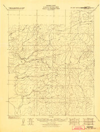
1945 Map of Tobias Peak
USGS Topo · Published 1945About this map
Hot Springs and the surrounding high country of the Sequoia National Forest anchor this mid-century tactical survey. The landscape is defined by the headwaters of the White River and Poso Creek, where steep drainages such as Starvation Creek and Nigger Creek carve through the Baker Range. Small outposts and named settlements like Pine Flat, Cranston, and Berry reflect a history of mountain habitation and forestry service, while landmarks such as Grist Mill Peak suggest early industrial attempts to harness the region's timber or water power. This map provides a detailed view of the terrain transitioning across the Tulare and Kern County line, documenting numerous mountain peaks including Tobias Peak, Sunday Peak, and King George Peak. For the genealogist or local historian, it identifies specific locales such as Holey Meadow, Double Bunk, and Dunlap Meadow that were part of the early twentieth-century backcountry infrastructure.
Find a feature on this map
33 named features on this map. Tap any name to fly to it.
Don’t see what you’re looking for? This feature index may not catch every label — zoom into the map to look around manually.
Map Details
Editions of this 1945 Tobias Peak Map
This is the sole edition of this map. No revisions or reprints were ever made.
Other maps of this area

1904 · Kaweah
USGS Topo · 1:125,000

1905 · Olancha
USGS Topo · 1:125,000

1905 · Fairview
USGS Topo · 1:24,000

1906 · Kernville
USGS Topo · 1:125,000

1907 · Olancha
USGS Topo · 1:125,000

1908 · Kernville
USGS Topo · 1:125,000

1909 · Kaweah
USGS Topo · 1:125,000
1918 · Fairview
USGS Topo · 1:31,680

1920 · Delonagha
USGS Topo · 1:62,500

1926 · Glennville
USGS Topo · 1:62,500