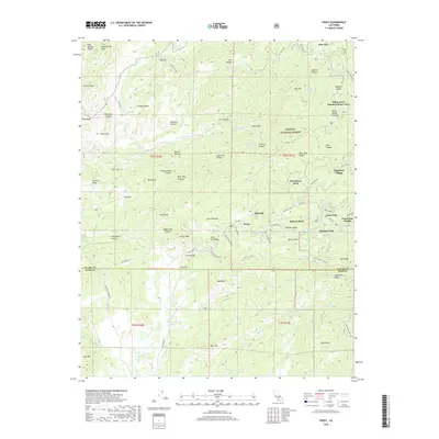
2018 Map of Posey
USGS Topo · Published 2018About this map
Idlewild and Posey serve as focal points for this 2018 survey of the southern Sierras, where the Tulare Co Kern Co line divides a landscape characterized by residential tracts and rugged drainages. The area is defined by several summer-oriented settlements and tracts, including Sugarloaf Village, the McClenney Tract, and Panorama Heights, illustrating the region's role as a mountain retreat within the Sequoia National Forest. Notable landmarks such as Balance Rock and Betty Waller Meadow are nestled among complex canyon systems like Yellow Jacket Canyon and Pumpkin Canyon. The White River and Poso Cr navigate the terrain, which transitions from high peaks like King George Peak down toward the Bald Hills. Historically significant routes like Old Stage Rd still traverse the land, connecting former foothill communities and providing a blueprint of the historical transit network between the mountain camps and the valley below.
Find a feature on this map
97 named features on this map. Tap any name to fly to it.
Don’t see what you’re looking for? This feature index may not catch every label — zoom into the map to look around manually.
Map Details
Editions of this 2018 Posey Map
This is the sole edition of this map. No revisions or reprints were ever made.
Other maps of this area

1920 · Delonagha
USGS Topo · 1:62,500

1926 · Glennville
USGS Topo · 1:62,500

1932 · Woody
USGS Topo · 1:62,500

1935 · Woody
USGS Topo · 1:62,500

1936 · White River
USGS Topo · 1:62,500

1936 · Tobias Peak
USGS Topo · 1:125,000

1943 · Tobias Peak
USGS Topo · 1:125,000

1945 · Tobias Peak
USGS Topo · 1:62,500

1948 · Bakersfield
USGS Topo · 1:250,000
1952 · Woody
USGS Topo · 1:62,500