1952 Map of Potlatch
USGS Topo · Published 1964About this map
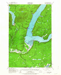
The Skokomish Indian Reservation anchors the southern landscape of this 1952 study, where the Skokomish River meets the tidal flats of Annas Bay at The Great Bend. This junction of fresh and salt water defines the regional geography, with the Hood Canal curving sharply eastward past Potlatch and the town of Union. The map illustrates a rural economy transitioning from timber to recreation, shown by the extensive Olympic National Forest boundaries and the presence of Lake Cushman. Social centers of the era are visible through several localized institutions, including the Skokomish Valley Sch, the Indian Sch, and the Tahuya School. Along the western shoreline, Hoodsport serves as a gateway to the steep terrain of Cushman Hill and Dow Mtn, while the Pacific Northern rail line tracks across the lower terrain.
Find a feature on this map
97 named features on this map. Tap any name to fly to it.
Don’t see what you’re looking for? This feature index may not catch every label — zoom into the map to look around manually.
Map Details
Editions of this 1952 Potlatch Map
3 editions found
Historical Maps of Union Through Time
39 maps found

1943 Nahwatzel Lake
Mason County, WA

1943 Potlatch
Mason County, WA

1952 Potlatch
Mason County, WA

1953 Lake Wooten
Mason County, WA

1953 Mason Lake
Mason County, WA

1953 Mt Tebo
Mason County, WA

1959 Squaxin Island
Mason County, WA

1981 Matlock
Mason County, WA

1981 Nahwatzel Lake
Mason County, WA

1985 Eldon
Mason County, WA

1985 Lilliwaup
Mason County, WA

1985 Mt Washington
Mason County, WA

1986 Skokomish Valley
Mason County, WA

1990 Dry Bed Lakes
Mason County, WA

1990 Lightning Peak
Mason County, WA

1990 Mount Olson
Mason County, WA

1990 Mount Skokomish
Mason County, WA

1990 Mount Tebo
Mason County, WA

1990 Vance Creek
Mason County, WA

1997 Mason Lake
Mason County, WA

1997 Squaxin Island
Mason County, WA

1999 Lake Wooten
Mason County, WA

1999 Mount Olson
Mason County, WA

2023 Dry Bed Lakes
Mason County, WA

2023 Eldon
Mason County, WA

2023 Lake Wooten
Mason County, WA

2023 Lightning Peak
Mason County, WA

2023 Lilliwaup
Mason County, WA

2023 Mason Lake
Mason County, WA

2023 Matlock
Mason County, WA

2023 Mount Olson
Mason County, WA

2023 Mount Skokomish
Mason County, WA

2023 Mount Tebo
Mason County, WA

2023 Mount Washington
Mason County, WA

2023 Nahwatzel Lake
Mason County, WA

2023 Shelton Valley
Mason County, WA

2023 Skokomish Valley
Mason County, WA

2023 Squaxin Island
Mason County, WA

2023 Vance Creek
Mason County, WA