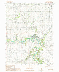
1984 Map of Potomac
USGS Topo · Published 1985About this map
The Middle Fork Vermilion River carves a winding path through this corner of Vermilion County, defining a landscape of agricultural plateaus and riparian conservation. The village of Potomac serves as a central hub, where the local High Sch and Po sit near an Old Railroad Grade that hints at the area's former transit importance. This 1980s data records a transition toward recreational land use, specifically within the Middle Fork State Fish and Wildlife Area, while preserving deep-rooted local history through scattered pioneer and family burial sites like Old Partlow Cem and Ingersoll Cem. To the west, the settlement of Armstrong remains a distinct marker of the rural township structure, connected to its neighbors by a network of drainage features such as Bluegrass Creek and Knights Branch.
Find a feature on this map
28 named features on this map. Tap any name to fly to it.
Don’t see what you’re looking for? This feature index may not catch every label — zoom into the map to look around manually.
Map Details
Editions of this 1984 Potomac Map
This is the sole edition of this map. No revisions or reprints were ever made.
Other maps of this area

1899 · Danville
USGS Topo · 1:62,500

1900 · Danville
USGS Topo · 1:62,500

1931 · Fithian
USGS Topo · 1:48,000

1933 · Hoopeston
USGS Topo · 1:48,000

1936 · Potomac
USGS Topo · 1:62,500

1938 · Hoopeston
USGS Topo · 1:62,500

1943 · Fithian
USGS Topo · 1:62,500

1948 · Danville NW
USGS Topo · 1:24,000

1950 · Danville NW
USGS Topo · 1:24,000

1953 · Danville
USGS Topo · 1:250,000