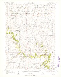
1957 Map of Potomac
USGS Topo · Published 1958About this map
The Middle Fork Vermilion River and its numerous tributaries, including Bluegrass Creek and Whisky Creek, define the rural landscape of this east-central Illinois region. In the late 1950s, the area remained a network of small agricultural settlements and crossroads connected by the New York Chicago and St Louis and Illinois Central railroads. Several small communities such as Potomac, Rankin, and Penfield anchor the townships, while the hinterlands are dotted with markers of early pioneer settlement. Genealogists will find a high density of family and parish burial grounds, including Tomlinson Cem, Partlow Cem, and St Lawrence Cem. The presence of an abandoned Science Hill Sch and numerous country churches like Wallace Chapel reflects the shifting population centers of the mid-20th century. River crossings like Selsor Ford and Grey Ford underscore the era's persistent connection to the natural hydrology before modern bridge infrastructure dominated.
Find a feature on this map
54 named features on this map. Tap any name to fly to it.
Don’t see what you’re looking for? This feature index may not catch every label — zoom into the map to look around manually.
Map Details
Editions of this 1957 Potomac Map
2 editions found
Other maps of this area

1899 · Danville
USGS Topo · 1:62,500

1900 · Danville
USGS Topo · 1:62,500

1906 · Urbana
USGS Topo · 1:62,500

1924 · Paxton
USGS Topo · 1:62,500

1927 · Paxton
USGS Topo · 1:62,500

1931 · Fithian
USGS Topo · 1:48,000

1933 · Hoopeston
USGS Topo · 1:48,000

1936 · Potomac
USGS Topo · 1:62,500

1938 · Milford
USGS Topo · 1:48,000

1938 · Hoopeston
USGS Topo · 1:62,500